Bighorn National Forest
Legal notice: Royal Flyfishing.com assumes no responsibility for any website links mentioned in this report and their content. No liability is accepted for external links. Website links in text will be removed by us if we are informed that the respective website operator does not agree or the website no longer exists. Copying photos, graphics and text is not permitted.
all fotos copyright: Eva Geigl / Royal Flyfishing
Devil's Kitchen is a 115 acre geologic feature, about five miles east of the town Greybull.
Breathtaking views, an incredible geological beauty.
Badland, craters, cliffs and rock formations in many colors and shapes have been created by nature.
More information about „Devil's Kitchen“ geology : https://www.bighornbasindinos.org/devilskitchen
More about "Devil's Kitchen" at the website „360°Cities“ (panoramic view).
https://www.360cities.net/image/devil-s-kitchen-vista
https://www.360cities.net/image/devil-s-kitchen-run-off-erosion-pattern
https://www.360cities.net/image/devil-s-kitchen-sandstone-hummocks
https://www.360cities.net/image/devil-s-kitchen-north-alcove
https://www.360cities.net/image/devil-s-kitche-yellow-and-red-towers
Shell Creek (a tributary of the Bighorn River) flows along the impressive Bighorn Scenic Bayway (US Hwy 14), surrounded by sandstone mountains that are around 550 million years old and resting on 2,9 billion year old Precambrian rocks, one of the oldest rocks on earth... such interesting information and many other, e.g. about the flora and fauna of Shell Creek, is available at a rest area where there is a visitor information center (the Shell Falls Interpretive Site) and is located near Shell Canyon. A stairway with a viewing platform leads almost directly to the waterfall. Shell Creek is named after the mussel fossils that were found in the sediment walls of the canyon. The waterfall is about 120 feet high. Deep down in the large pools, that are inaccessible to everyone, we actually have seen a lot of big trout.
A somewhat longer and dusty unpaved road leads to the South Tongue River and encounters with moose crossing this road from forest section to forest section are very common. The South Tongue River is crystal-clear and partly tight meandering and therefore flows at different speeds. At the flat sections of the river the bottom was very boggy and overgrown with aquatic plants and we could there only fish from the shore. The beautiful surroundings in the forest or on the open plain, the tranquillity and the absolutely high fish population tempted us to stay there for two days. We caught lots of brown trout in various sizes.
Tributary of the South Tongue River. A beautiful stream, very clear water with plenty of Brook Trouts.
Lots of experiences along this river - flyfishing among piles of wood. Many Brook Trouts were very hungry for our flies. Around our Motohome late in the evening: a deer and a moose cow with calf. Hidden history there at an elevation of 8,400 feet: a construction of a “splash dam” occurred around 1905. An old transportation system for the movement of logs and railroad ties from the forest to sawmills in the valley. There are several over 100 years old splash dams in the Big Horn Range, including one on Sourdough Creek. All of these dams were important sites for timber processing, as ties were needed for the railroad industry - they float the ties to Clear Creek to meet the railroad east of the town Buffalo. And much timber were needed for building materials for settlements.
Every mile of the North Tongue River looks different at this high elevation of 8400 feet. In the forest with lodgepole pines, spruces and Douglas firs the river is wild with large pools, and in the flat narrow and slow-flowing. We caught a lot Yellowstone Cutthroat Trout and Rainbow Trout.
The Tongue River is a tributary of the Yellowstone River in Montana. It rises in the Big Horn Mountains from elevation of about 10.000 feet and flows about 250 miles to southeastern Montana and empties into the Yellowstone River at Miles City. We visited the magnificent and impressive Tongue River Canyon (about 5 miles away from Dayton), where there are three official flyfishing accesses. We have caught only brown trout here. An unpaved path along the river takes you through millions of years old sedimentary rock, limestone, shale and sandstone to a parking lot, where the beautiful drive through the canyon ends. From here you can continue hiking alongside the very nice River.
We visited the Jim Gatchell Memorial Museum with The Nate Champion statue. He is famous for his last stand in 1892 during the Johnson County Cattle War.
And we visited the Historic Occidental Hotel, founded in 1880. The hotel was visited by many famous people of the Old West, for example: Butch Cassidy, Sundance Kid, cattle detective and killer Tom Horn, Buffalo Bill Cody, Ernest Hemingway, General Phil Sheridan, author Owen Wister who stayed in this hotel for 3 years, President Theodore Roosevelt, President Herbert Hoover and actor Hugh O'Brian.
About 15 miles from Buffalo City, on Hwy 16 (towards Ten Sleep City), both rivers flow through fairytale forests of the Bighorn NF. Somewhat difficult to fish, but we caught lots of brown trout on both rivers. Wild natur.
not only women go crazy here...
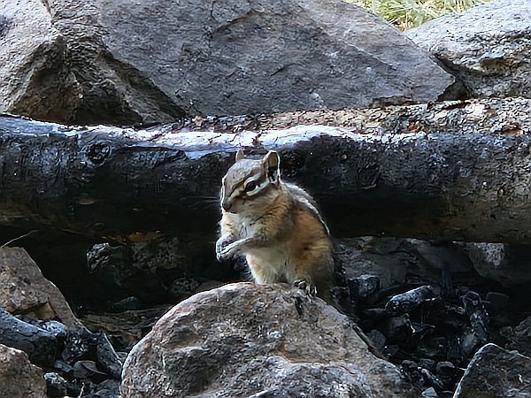
We caught more Brook Trout at the Crazy Woman Creek than ever before - every cast a bite, no matter which dry fly. The creek meanders many miles deep into the wood and it was almost spooky - we had to pay close attention to whether a bear or moose was on the move as we found many tracks. But a little forest dweller took care of us...a squirrel.
There is a small turnoff from US-Hwy 16 (from Buffalo City to Tensleep) onto Canyon Creek Rd. (25) which after a few miles leads to Canyon Creek, which meanders both on the high plains and in the forest at about 9000 ft. The dirt road is somewhat difficult to navigate and it takes time with the motorhome to find a spot to fish the creek. If you drive further, the road becomes even narrower and steeper and you can no longer get to the river. We then also had a problem with the possibility of turning back with the Motohome.
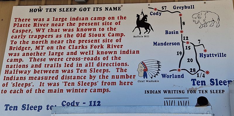
The drive through Tensleep Canyon is highly impressive. The Hwy 16 winds through the mountain cliffs. An eldorado for experienced sport climbers, at a dizzying mountain altitute. In the canyon with a Motohome it is difficult to get to Tensleep Creek and fish, the unpaved paths down to the river are narrow and very steep. But about 10 miles before Ten Sleep City you enter the valley and it becomes flatter and there are also official fly fishing access points and the hike to the river is much easier here. The Tensleep Creek flows very wildly in places, with many rapids and large pools, and flows into the Nowood River, which is a tributary of the Bighorn River. Near at Tensleep City you can visit a fish hatchery which breeds over 2 million fish a year: Rainbow, Yellowstone Cutthroat Trout, Brook Trout and many more. Information on the website: https://wgfd.wyo.gov/ten-sleep-fish-hatchery

On the way to Medicine Bow Routt National Park, we drove through Natrona County to Capser (the second largest town in the US state of Wyoming) on the North Platte River.
On the way to Saratoga we visited the Little Medicine Bow River and the Medicine Bow River. We didn't fish there because in this vast and flat Natrona area, it was very hot (about 105 °F) and the air was also very bad and cloudy (dense smog) due to various wild fires in the area.
It wasn't until well after Saratoga City and higher up in the mountains of Medicine Bow National Forest that we could really better breathe again and the temperatures were much more pleasant.

